Newton-King George Boulevard Plan Nears Approval
The City of Surrey Council approved Phase 1 of the proposed Newton-King George Boulevard Plan back in June 2021, now the plan is being finalized for imminent council approval.
In this post, we examine key points of the plan, its background, and its future. We will also look at how this plan could affect property and business owners in the Newton-King George Boulevard area and the surrounding neighbourhoods.
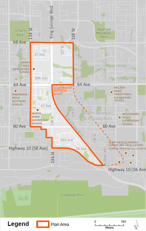
The Newton-King George Boulevard Plan comprises of approximately 167 hectares (413 acres) of land between Highway 10 and 68 Avenue. It is a part of TransLink’s Frequent Transit Network and the location of future RapidBus Service.
What Happened
- October 2019: Council endorsed initiating the planning process for Newton-King George Boulevard, which did not have a secondary plan and was dominantly designated “Urban” in the Surrey Official Community Plan
- October 2020: Council approved amending the plan area boundary to include a small area just west of the original Plan Area
- Spring 2021: public input was collected from residents on the draft plan
- June 28, 2021: Council approved the Stage 1 Plan, Land Use, Transportation, and Parks and Amenities Concepts, as well as directed staff to keep working on the Stage 2 (final) plan
- Summer 2022: further public feedback was collected on the plan as staff worked on the community benefit planning, development of urban design guidelines, as well as engineering and financial analysis
- Next Steps: A 5-step process & timeline serves as a guidepost to track planning progress. The process is currently at step 4, “ refining the plan”. Stage 5 is “completing the plan”, which we elaborate on later in this article

What This Means For Property And Business Owners
Property and business owners, as well as those in the market for real estate in the Newton-King George Boulevard area, can expect the following:
Changes in Land Use Designation & Property Values
- This new plan was brought on by the need for a coordinated plan use to guide the future development of the area
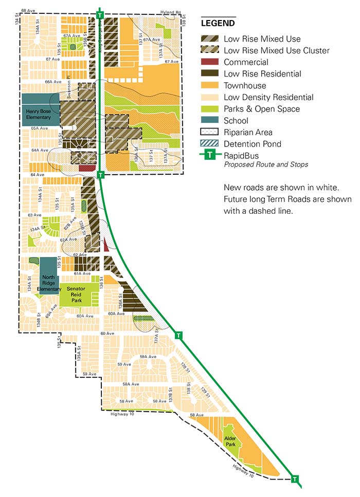
- The plan will give every property within the area a land use designation (see draft land use plan below). This will define what type of development could be built on each property within the plan if a landowner chooses to go through a rezoning and development application process
- A change in land use can change the value of a property due to its new development potential
- While existing land owners are not forced to re-develop, move, or sell their properties, properties with increased density allowance (based on the plan) can expect increased attention from Realtors and developers
- In addition, the City will offer fair-market value to purchase properties outlined for parks when they become available for purchase
New Development
- New development is expected to start appearing within a few years following plan approval
- The plan introduces new commercial and residential redevelopment opportunities as well as opportunities for infill development
- Density is focused along King George Boulevard, near RapidBus stops
- New residential developments will include a mix of low-rise apartments and townhouses
- New commercial developments along King George Boulevard will be dominated by low-rise, mixed-use development
Increased Connectivity through Transit & Walk/Bike-ability
- The Transportation Concept envisions four new RapidBus stops on King George Boulevard at Highway 10, 60th Avenue, 64th Avenue, and 68th Avenue
- It also highlights road upgrades to include protected cycling lanes, new roads to improve walkability, and pedestrian pathways
- Increased connectivity can increase visitors to an area boosting business while also making the area more accessible and enjoyable to residents from all walks of life by providing new transport and decreasing car traffic
New & Protected Green Areas
- The Parks and Open Space Concept proposes expansions for four existing parks, two new large natural area parks, and the prohibition of new development for the existing riparian ecosystem around water courses
What’s Next
The Plan is currently at the 4th Step in its 5-step process & timeline. During the 4th step, designated staff will evaluate where changes need to be made based on the community feedback collected through a recently concluded August 19, 2022 survey.
The 5th and final step involves staff reporting back to the community before seeking the endorsement of the Final Plan by the Council. This step includes:
- Detailed engineering and financial analysis
- Community benefit planning
- Development of urban design guidelines
More information on the Newton – King George Boulevard Plan can be found on the City of Surrey Website.